A web/android application for indoor location services (2020-2021)
Keywords: Assistive technology, user interface design, user experience design, system design
Client: © Indian Institute of Technology Delhi
Funded by: World Health Organization South East Asia Regional Office
Role: Design lead (consultant)
Co-designed with: Assitech Lab, School of it & Department of Design, iitd
Publications: Upadhyay, V., Arun Kumar, P., Singh, P., Ayush, Sharma, S., Paldas, S., Rao, P. V. M., Balakrishnan, M. (2021). Retrofit Framework for Indoor Mobility in Unstructured Spaces. Workshop Paper in CHI 2021, Yokohama, Japan. https://cdn.disabilityinnovation.com/documents/CHI-Workshop_submission_10.pdf?mtime=20210325101720&focal=none
Persons with visual impairment frequently face difficulties in access to information while navigating through built environments. This problem is exacerbated by unstructured and poorly documented environments in the global south. While some of the challenges of outdoor navigation have been overcome through smartphone applications over the past 10 years, indoor navigation continues to be a pressing challenge for the growing population of persons with visual impairment.
The Inclunav project focuses on improving access to information for navigating through indoor environments. While the project identifies people with visual impairments as a critical audience, the products have been designed for universal access. The project consists of two digital applications; Inclunav Maps and Inclunav Routes.
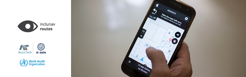
Inclunav Routes is a web & android application designed to provide indoor location services to the user. The product uses navigation cues and maps generated on Inclunav Maps to produce an interactive navigation system for indoor spaces. The product has been designed for interfaces suited to sighted, low vision and persons with complete blindness respectively. Furthermore, specific route finding algorithms have been developed to identify suitable routes for users on wheelchairs, pregnant users or those with trolleys. The product is currently being tested at iit Delhi, National Association for the Blind, R. K. Puram and aiims Delhi.